Brothers Island Lighthouse New Zealand
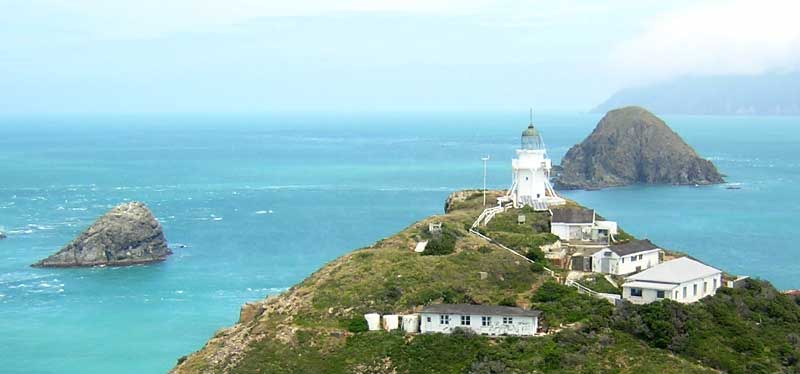
The Brothers (Māori: Ngāwhatu-kai-ponu) is a group of small islands in Cook Strait, New Zealand, off the east coast of Cape Koamaru, Arapaoa Island. North Brother (left) and South Brother Extract from Chart NZ 46 Cook Strait Arapaoa Island (formerly spelled Arapawa Island) is an island located in the Marlborough Sounds, at the northeast tip of the South Island of New Zealand. The island has a land area of 75 km2 (29 square miles). Queen Charlotte Sound defines its western side, while to the south lies Tory Channel, which is on the sea route between Wellington in the North Island to Picton. Cook Strait’s narrowest point is between Arapaoa Island’s Perano Head and Cape Terawhiti on the North Island. The islands are a restricted-access wildlife sanctuary administered by the Department of Conservation. The southern end of Arapaoa Island Islands The Brothers form two small island groups, each containing one main island and a number of tiny islets. The main islands are simply called North Brother and South Brother. South Brother is the larger of the two, covering some 9.5 hectares (23 acres), but the 4-hectare (9.9-acre) North Brother is slightly more elevated, rising to 66 metres (217 ft). Most of the smaller islets lie in a small arc south of North Brother, with the largest being only someone hectare in area. History The Māori name for the group, Ngāwhatu-kai-ponu, literally means “the eyes that witnessed” and according to tradition, it refers to the eyeballs of the giant octopus, Te Wheke-a-Muturangi, that Kupe battled. The islets were considered tapu to Māori. Paddlers making their first crossing of Raukawa/Cook Strait were blindfolded as it was considered bad luck to see the islands on their first crossing. Detail of Kupe and his wife Kuramarotini from the statue on the Wellington waterfront During Captain James Cook’s first visit to the area, HMS Endeavour was very nearly wrecked on the Brothers, as a lack of wind and strong tide drove the ship towards the rocks. A change in the direction of the tide saved the ship. Lighthouse The Brothers Island lighthouse is located on the summit of North Brother. The lighthouse was built in 1877 and is New Zealand’s only rock station. It replaced the Mana Island lighthouse. The first call for a lighthouse on the Brothers was in 1851 after the Maria sank near Cape Terawhiti. A plaque near where the Penguin is thought to have sunk was unveiled 100 years after the tragedy. Beach between Cape Terawhiti and Sinclair Head, Wellington, with the raft used for recovering bodies after the wreck of the Penguin Find out more about the tragedy of the Penguin by clicking here When a lighthouse was erected on Mana Island to serve Cook Strait comment was made in the Marlborough Press that despite the expense it would have been better to have put one on the Brothers. This request was again repeated in the Evening Post in 1870. In 1872 the barque City of Newcastle was lost because the Captain mistook the Mana Island light for the entrance to Wellington Harbour. In 1874 a report titled New Zealand Coast Lights by Captain Johnson was tabled in Parliament and among others recommended removing the Mana Island light in favour of light on the Brothers. Construction of the lighthouse was difficult because of its isolation and lack of fresh water. Building materials for construction were unable to be delivered to the island for 2 months because of the weather and sea conditions. Workers had to construct huts as tents could not be pitched on the rock. The oil-powered light began operation on 24 September 1877. This was replaced in August 1954 by electricity supplied by a 10hp diesel engine coupled to three 6.8kw generators. A further upgrade occurred in August 1990 when the light was switched to a 50-watt tungsten halogen solar-powered beacon and fully automated. The light was manned by a lighthouse keeper until August 1990. Since then the light has been remotely monitored from Wellington. The light isolation was very hard on the keepers and supplying the island challenging. Supplies were bought in from Picton and the lighthouse keepers provided weather reports on local conditions at 4.30 am daily, then every hour on the hour till 4 pm. Lighthouse overview The Brothers Island Lighthouse is New Zealand’s only rock station. Extremely isolated and desolate, the Brothers Islands are situated on the western side of Cook Strait. Lighthouse feature: Details Location: 41°06’ south, longitude 174°26’ east Elevation: 79 metres above sea level Construction: wooden tower Tower height: 12 metres Light configuration: modern rotating beacon Light flash character: white light flashing on every 10 seconds Power source: batteries charged by solar panels Range: 19 nautical miles (35 kilometres) Date light first lit: 1877 Automated: 1990 Demanned: 1990 Getting to Brothers Island Lighthouse Brothers Island Lighthouse is inaccessible to the public. There is no public access to enter the lighthouse The island is now a restricted-access wildlife sanctuary administered by the Department of Conservation. It is home to tuatara and numerous other endangered species. Find this on the map: Brothers Island The History of Brothers Island Lighthouse The Brothers Island Lighthouse, built in 1877, replaced the light on Mana Island, which sailors often confused with the light at Pencarrow Head. The lighthouse was built on the larger of the two islands. The tower was built on the highest tip to provide all round visibility of the light. The island is an extremely isolated and desolate rock, which made building the lighthouse a challenge. There was not enough soil for the workmen to pitch their tents. They were forced to build huts for their accommodation. There was no drinking water on the island and all water, food and supplies had to be shipped in.